
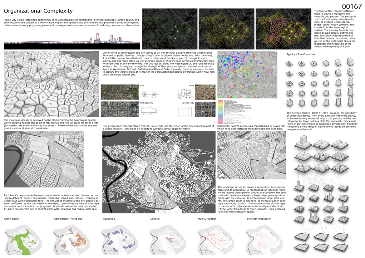
Organizational Complexity
 ‘Rome City Vision’ offers the opportunity to re-conceptualize the relationship between landscape, urban design, and architecture in the context of a historically complex and dynamic city environment. Our proposal creates an integrated urban vision whereby programs, spaces, and typologies are interwoven as a way of producing provocative urban vision.
Unlike works of architecture, the city serves as an icon through patterns from the urban fabric’s form and its public features. Though a city’s plan is seldom visible to the eye from the street, it is still the means an individual’s uses to understand the city as place (through its maps, subway and bus route plans, as well as green space). Thus the plan serves as an important icon for inhabitants of the environment. For this reason, cities like WashingtonDCand Paris resonate in their collective imagery, through the strength of their plans as figures: the mall as a central figure in WashingtonDCand Radial road pattern of Paris. However, these figures were not able to capture the vibrant chaos of Rome, nor the deregulated democratic differences within New York City’s seemingly regular grid.
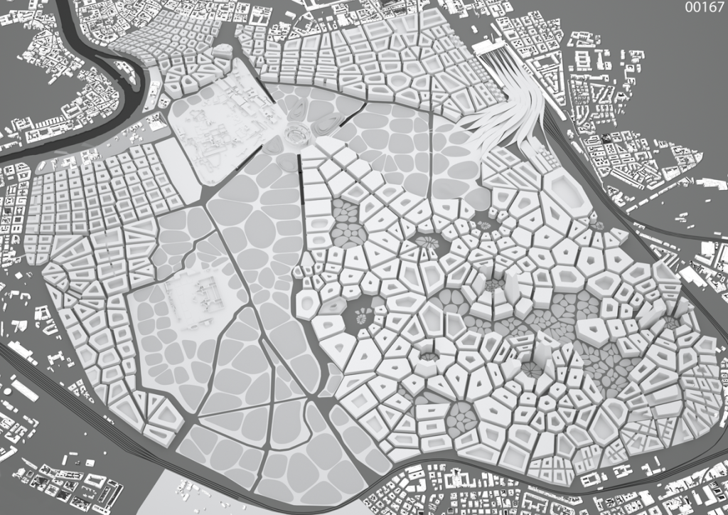
If one sees the potential from these examples, our challenge forRome is to ensure the symbolic charge of the former, while also guaranteeing the urban energy of the latter. The logic of the ‘voronoi’ pattern is used to create a malleable and versatile grid pattern for this seemingly contradictory mandate. The patterns ‘natural’ geometry offers advantages a strict grid cannot. Creating an urban fabric that is able to conform to deformations of the land, topography, and spatial restrictions. The pattern is stretched and squeezed parametrically, to produce urban spaces, plazas, lawns, urban corridors and streets from the same logical system. The existingRome is composed of typologically distinct entities, the softly swaying pattern of lines that defines the streets, paths as well as the built fabric allows the mediation and integration of the various heterogeneity ofRome. This morphological system allows for infinite variation within the bounds of a strong formal coherence and sense of identity.
The city’s skyline serves as the plan’s counterpoint; it is the only way to comprehend the city as a single image from an actual perspective. For instance, one recognizes the difference between Parisand New Yorkimmediately through their iconic buildings, which compose the skyline (the EiffelTowerand the EmpireStateBuilding). Historically Rome’s skyline was characterized by seven hills, which have been depleted through reduction from development. The proposed skyline will revive Rome’s iconic verticality by mimicking the hills in its roofscape. The roofs are arranged and constructed mimicking the proposed topography (while respecting the morphological planning of the blocks, their heights and setbacks) giving Romea strong sense of identity within rich diversity. Concurrently, a wide variety of built volumes – tall, low, wide, and small – are brought under the flow of a unifying force. The concept of the gently undulating urban wave-form gives a sense of spatial coherence that is currently absent in Rome.
The green space extends nature from the lower hills into the center of the city, becoming part of a green network; serving as an important symbolic central space for Rome (reminiscent of New York City’s ‘Central park’). The landscape serves to create a connection between the place and its geography. A roundabout for vehicular traffic will be located underground, around the Coliseum. The ground level’s landscape creates a large urban plaza synchronizing with the coliseum to accommodate large-scale events.
This green space is extended to the train station canopy’s undulating pattern. The amalgamation of landscape to the station’s roofscape allows for multiple scales of activity to occur from large to more intimate, while enabling fluid movement between spaces. Rather than as a single surface, the conception of the city as multiple sectional layers enables the proposal to contain large areas of programme just above & below the city grid, supporting local pedestrian movement through the site without the boundaries normally imposed by streets.
The blocks have been designed as ‘natural’ extensions of the neighboring districts in the context of the master plan, using the topography of the surrounding landscape to define local geometries. The average block is 100M X 100M, creating the possibility of pedestrian access from every direction within the blocks, while maintaining an overall length that permits healthy development for large building plots.
Two design guidelines have been brought to establish a relationship between the design of the blocks and their subsequent subdivision. The proposal creates variations in plot dimensions to encourage development flexibility—enabling a wide range of development based on economy, program, and demand. The proposal has also established a more disciplined framework of building heights and densities that can produce a more consistent image of the city as an organic whole. Each block’s height varies between ten stories and four stories, dictated according to different zones: commercial, residential, mixed-use, cultural, creating an urban wave within consistent form.The exceptions to this logic are historically relevant architecture and several towers that serve as center points of the city. The maximum density is achieved on the blocks framing the commercial centers where building heights can go up to fifty stories and free up space for green areas (for nearby residential and mixed use zones). These towers encircle the site and give it a virtual skyline at its perimeter. The towers serve as geographic anchors for multiple centers of the site, giving a topographic measure to the undulating massing of the city.
The undulating massing of the city blocks is further reinforced by the sustainability mandate, committing the idea of landscape not simply as a metaphor but pragmatic. Roofs will reduce the heat island effect by mandating green roofs for the city to control storm water drainage and reduce solar gain for buildings.


Info:
Title: Organizational Complexity
Time: 17 marzo 2010
Category: Rome
Views: 14894 Likes: 1
Tags: -