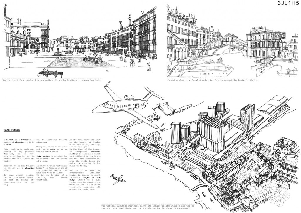

DIS-ORIENTIREENG VENICE


DIS-ORIENTIREENG VENICE […]No matter what you set out for as you leave the house here, you are bound to get lost in these long, coiling lanes and passageways that beguile you to see them through, to follow them to their elusive end, which usually hits water (…). On the map this city (…) has no north, south, east, or west; the only direction it has is sideways. It surrounds you like frozen seaweed, and the more you dart and dash about trying to get your bearings, the more you get lost. The yellow arrow signs at intersections are not much help either, for they, too, curve. In fact, they don’t so much help you as kelp you. [1]
INTRODUCTION: from the Grand Tour on Venice has been the favorite destination for travelers who loved to wander and get lost in its lanes and passageways. Today, the high diffusion of GPS is depriving visitors of the “unexpected”, which allowed them for centuries to bump into continuous discoveries out of serendipity. Venice is commonly considered an inevitable destination for the increasing number of travelers, a real “Mecca” for the fideistic international tourism religion. Low airline fares and bursting emerging tourist markets have dramatically reduced the time travelers spend in town and itineraries and destinations have consequently been rationalized. That is why Venice has become a “non-place”, a sort of terminal for more and more tourist floods and city users having no strict bounds with this city.
Both tourists and city users live and experience the city following ready-made itineraries, different by aim and development, but similar as for repetitiveness and partiality.
The standardization of urban itineraries has caused traffic congestion, which has consequently led to the dislocation polarization of business activities and services, and has raised issues of decorum and public order to the detriment of the inhabitants, who often feel alien and isolated in their own town. Indeed, the inhabitants are growing more and more intolerant towards visitors and try to contain their hatred just because they are attracted by the possibility to exploit them for profit.[2]
THIS PROJECT’S AIM: to hand out visitors, tourists and city users the pleasure of discovering another Venice by proposing a recreational use of the itineraries, different from the tourist ones. This will allow visitors to rediscover beautiful places that otherwise would stay unknown[3] and will also encourage the old practice of the flanerie. Moreover, this process aims at triggering demographical dynamics, above all encouraging a balanced demographical urban distribution (almost abandoned areas and over-pressurised areas) and the consequent possibility of equally redistributing the services which nowadays tend to be polarized where mobility junctions and tourist floods are. Finally, this project aims at spreading a better knowledge of Venice far from clichés, above all for those who have a continuous relation with this city for job purposes but choose to live in the mainland; therefore, this could also encourage people to go and live in the city centre.
PROJECT
DIS-ORIENTIREENG VENICE is not a project of architecture but a socio-cultural edutainment initiative that aims at changing the city through the evolution of the human factor.
DIS-ORIENTIREENG VENICE is a recreational device arising from the willingness to undergo a “drift” activity (a recreational, sport or educational drift activity) within the city of Venice, an accidental, unexpected exploration that can enrich visitors.
DIS-ORIENTIREENG VENICE is based on the human inbred recreational willingness and on a series of (un)informative spots physically represented by landmarks scattered in centrally located or very busy places and in less renowned places, to which we want to draw the attention of inattentive tourists or city users.
The experience will start when arriving in town, at transport terminals and at the hall of accommodation facilities, through the informative action of tourist promotion entities which will involve users inviting them to take part and handing them in for free one first itinerary to follow. Following this track visitors will enter urban portions which are usually at the edges of tourist perception and will finally wander at little “hidden” masterpieces.
Little “W.is” (Where is?) will be placed within the city where they can easily be reached. Users will be enabled to interact with them through a touch screen system and could decide whether to continue their experience asking for a new random itinerary or to disrupt their experience inserting a coin and getting a detailed map featuring the fastest way to reach the railway station, the Maritime terminal or the desired hotel.
Each “W.is” will be connected with the portal of the Centro Maree of Venice Municipality (a centre that forecasts and alerts on the high tide, translator’s note) and with the INSULA platform and will therefore provide inhabitants with real-time information on the tide and the high tide geography within the town, and will supply them with a map featuring a “dry” track for getting to destination. Inhabitants will take advantage of this service for free by using their local transport swipe card.
This system will also allow the Municipality to raise funds to reinvest in the protection and safeguard of the city, avoiding the tourist tax which was proposed by the Municipality Board and considered to be a theft by visitors. Through a little voluntary offering in return of an enriching sensory experience visitors and city users will be proud to support the safeguard of one of the wonders of Humanity.
Each “W.is” will be equipped with a little photovoltaic cell that will ensure a partial energy autonomy; the cell will redistribute energy through a system of light sockets that anybody could use to recharge their mobiles or little devices (multimedia readers, i-pods, i-pads). Moreover, a wi-fi booster will supply internet connection.
The “W.is” in its final shape should embody for contemporary Venice the same useful role, but also the same geographic reference and social centrality as the Venetian well for the Serenissima. Indeed, as the Venetian well used to collect rainwater through its drains and filter it through the sand for finally distributing drinking water, the new “W.is” will capture energy and information and after reprocessing them it will redistribute them to retail.
[1] Excerpt from WATERMARK by Joseph Brodsky. Copyright © 1992 by Joseph Brodsky.
[2] The propositions for a separate and private traffic for the inhabitants, several scam cases to the detriment of “non- Venetians” and the escape to the mainland as soon as job activities are over are noticeable examples.
[3] VENEZIA MINORE by Egle Renata Trincanato. Copyright © 1948 by Egle Renata Trincanato.


Info:
Title: DIS-ORIENTIREENG VENICE
Time: 7 giugno 2011
Category: Venice
Views: 3239 Likes: 7
Tags: Global Positioning System , Grand Tour , Joseph Brodsky , Republic of Venice , Scripps Institution of Oceanography , Tide , Venetian , Venice